|
|
||||
|
|
||||
 |
||||
|
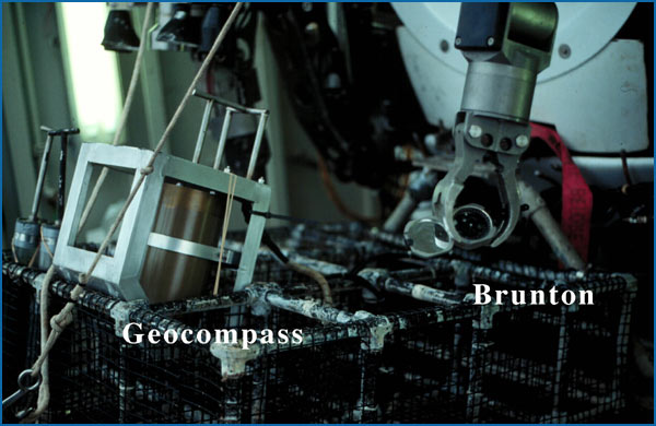
Tools to Measure Geological Features on the Seafloor Many important geologic features are easily represented by planes. These include horizontally deposited rocks, faults and fractures, dikes and sills, deformation fabrics within the rocks, and contacts between different rock types. Geologists can measure these different features by using a compass, which measures direction, and a clinometer, which measures inclination or the dip of a feature. But why would we want to? The answer is simple. By measuring geologic features, we can recreate geologic and tectonic actions that have taken place over time and reconstruct the history of an area.
Unfortunately, the Brunton compass used by most land geologists cannot be used on the seafloor. Bruntons are not built to withstand pressure at the seafloor, and even if they were, the compass’s small size makes them impractical for work with Alvin. Instead, geologists can use the Geocompass, built by Woods Hole Oceanographic Institution. The Geocompass houses a compass and two inclinometers, and can be held up against a rock outcrop on the seafloor. In this way, geologists can directly determine strike and dip, just as if they were measuring a feature on land. |
||||