|
|
||||
|
|
||||
 |
||||
|
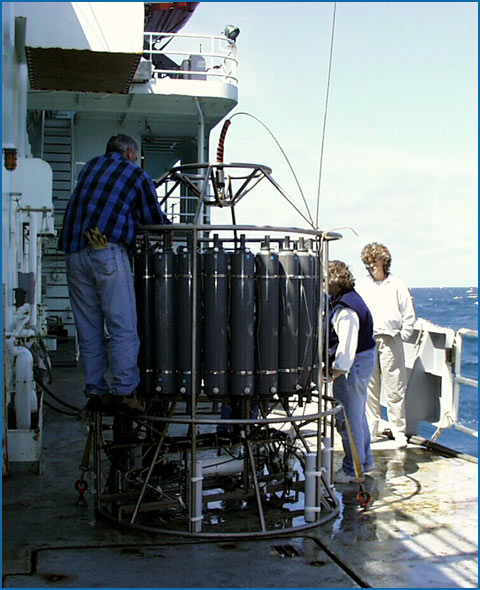
Water Column Discovering New Hydrothermal Fields-A CTD Package
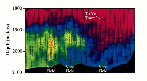
The instrument we will use is a Sea-Bird CTD system that is mounted on a tall, round metal frame, which hosts 24, 10-liter bottles for sampling fluids in real time. The instrument will also host oxygen, methane, and eH sensors, and a transmissometer that measures the amount of particulates in the water. This instrument is connected to the ship by a conducting wire, which allows an electronic signal to be sent down and up the wire. When the instrument is in the water, data is continuously transmitted to the ship, which allows us to measure the chemical, thermal, and particulate character of the water that the instrument is in or passing through. Each bottle mounted on the frame has two spring-loaded end caps that are fixed in the open position when the instrument package goes into the water—i.e. the bottles are a hollow tube with both ends open to the ocean. When we see an interesting anomaly in the water column we can electronically snap the end caps closed, trapping fluids immediately. In this way we can bring the instrument back onboard and retrieve the sampled hydrothermal plume water, which is later analyzed for its chemistry and also for its microbial content. What Does the Plume Look Like at Lost City? During this cruise we will use the CTD in two different ways. The first way, is by lowering the CTD into the water such that it goes directly beneath the side of the ship in a vertical path to just a few meters above the seafloor. During this process we keep the ship in a stationary position. Linkages between onboard computers, thrusters, and GPS satellites are so good and “smart”, that commonly when we do these casts the entire piloting of the ship is done under computer control. We use these “vertical water casts” to do pinpoint analyses of the water column. This will be a critical measurement when we first get to Lost City because it will provide us with a sound-velocity profile of the water column, which is important in acquiring good navigation. In addition, it will also give us a very good image of what the plumes looks like above Lost City—something we know very little about. How Will We Find New Fields? The mid-ocean ridge spreading network spans a distance of ~60,000 km. To find new sites of hydrothermal vents can sometimes be like looking for a needle in a haystack. To efficiently look for new fields we use first make educated guesses on where we might expect to find them based on the geology of the area. Usually, in a new area this means that we spend a lot of time looking at bathymetry maps, which may provide hints to where the fields are.
|
||||