The serpentinite-hosted Lost City Hydrothermal Field is a remarkable submarine ecosystem in which geological, chemical, and biological processes are intimately interlinked

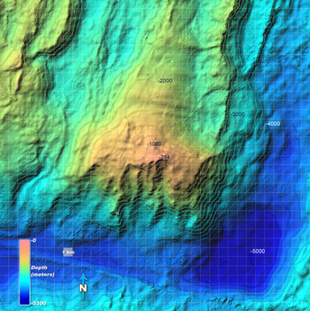
The Atlantis Massif rises ~14,000 feet above the surrounding seafloor and is formed by long-lived ...

Atlantis Massif

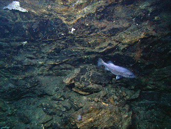
Highly deformed serpentinites direclty underlie Lost City. This image was taken with the robotic v ...

HIghly deformed serpentinite rocks at Lost City
The Lost City Hydrothermal Field is located 15 km west of the spreading axis of the Mid-Atlantic Ridge at 30°N, near the summit of the Atlantis Massif. The relief of this mountain is similar to that of Mt Rainier, rising nearly 4000 m (>17,000 feet) above the seafloor over a horizontal distance of ~20 km. Unlike Mt Raininer, however, the Atlantis Massif is not formed by volcanic eruptions, but instead by extreme crustal extension during long-lived (1-2 my) faulting and uplift. In concert, these processes have resulted in stripping-off of shallow crustal volcanic material and exposure of magnesium-rich mantle rocks (peridotites).
The summit of the massif is capped by flat-lying sedimentary breccias overlain by fossiliferous pelagic limestone. This cap rock was likely important in formation of the field, acting as an impervious lid trapping both fluids and heat. The cap rock is underlain by a 50-100 m thick highly deformed zone that hosts variable altered ultramafic rocks (foliated serpentinite, talc-amphibole schists) and lesser gabbroic rocks. This shear zone is likely the long-lived detachment fault that exposed the mantle and lower crustal rock sequences that make up the massif. This zone grades downward into massive, jointed peridotite with lesser gabbroic rocks that are not highly deformed.
Lost City Hydrothermal Field lies atop the sedimentary cap rock, on a triangular, down-dropped block that forms a terrace on the edge of the south wall. The largest and most active vents are along an east-west trending lineament more than 300 m long. The lineament is intersected by a ~north-south trending fault, which exposes massive, jointed outcrops of serpentinized rocks that form the major north-south ridge that Lost City rests on. The fracture and fault network in the basement provides permeable pathways that control outflow at the main vent sites. In addition to subvertical faults that channel flow to the largest structures, much of the subsurface flow emanates from surfaces that are parallel to basement to gently west-dipping faults. The steep faults expose relatively old, inactive stockworks of carbonate veins and subhorizontal to subvertical open fractures in the basement rock. These are actively leaking hydrothermal fluid and feeding young, white hydrothermal precipitates.


